The Landslide Blog is written by Dave Petley, who is widely recognized as a world leader in the study and management of landslides.

Being based in the UK, it is hard to keep track of the news from the US at the moment, but I watch with horror as the capability of science agencies (e.g. NSF), hazard management organisations (e.g. NOAA) and universities is systematically gutted. The ability of the US to identify and respond to the hazards it faces is being rapidly degraded from world-leading to barely functional. This will be a source of great regret in due course, and I can only sympathise with all those extremely capable people who are being treated so poorly.
Meanwhile, the hazards driven by our changing climate do not stop, no matter how much individual politicians may wish to believe otherwise. Over the weekend, Kentucky suffered exceptionally heavy rainfall, causing landslides and flooding. A very significant landslide was triggered at Fleming-Neon, which has caused significant damage. On first inspection, the landslide appears to be a classic case of the combination of extreme rainfall and human activity.
WLKY News Louisville has posted an excellent aerial video of the aftermath of the landslide, which captures its location and main features really well:-
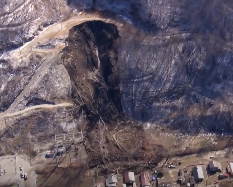
This still from the video tells a thousand stories:-

The location of this landslide is [37.1959, -82.6942] – there is a good archive of Google Earth images of the site. It is particularly interesting that the crown of the landslide is located in an area with a road and a large platform on the hillside. This is captured well in the Google Earth imagery – here from 2019:-

Where this gets interesting is a Google Earth image from June 2010, which appears to show the aftermath of work on that platform (which was already in existence prior to this point):-

It appears, although needs further investigation, that the platform was enlarged by cutting into the rear slope. The excavated material appears to have been placed on the downslope side – if so, this was a classic cut and fill operation.
My working hypothesis for the landslide, which needs verification, is that it could have been caused by failure of this emplaced fill. This would align with the image from the video, and the behaviour of the material at the foot of the slope is also consistent with this. The landslide entrained material downslope, but fortunately the runout stopped before destroying the houses on the other side of the road.
As such, this landslide has some similarity to the 21 May 2024 landslide on the Meida Highway in Guangdong Province, China. In the case of the landslide at Fleming-Neon, exceptional rainfall appears to have combined with possible sub-optimal engineering to create a destructive landslide. There are many similar locations in the USA and across the world.


